Chess Board Land Patterns in North America
Posted on Friday, May 7th, 2010
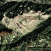
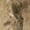
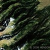
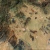
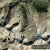
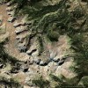
These ŌĆ£chess boardsŌĆØ show up on Google Maps and Bing Map Satellite images. In my opinion these patterns werenŌĆÖt done within the last 600 years for the following reasons:
- They all show significant signs of deterioration.
- They would be extremely expensive to have been done recently.
- What would have been the purpose of these patterns? (ItŌĆÖs one thing to mow beautiful diagonal patterns in the grass outfield of a baseball stadium. This is far more substantial and long lasting).
- These Land Patterns (Just Like the Geoglyphs, Black Water Lakes and Altered Islands) Can Only Be Seen From High Altitude.
These patterns probably from ancient times were tied into the then current system of coordinates that preceded the Chinese Quantitative Rectangular Grid Mapping System of Zhang Heng (78-139 AD) and later perfected by Phei Hsiu (Phi Xiu)- (Pages 540 & 542 Science and Civilization in China, Volume III Joseph Needham) ŌĆ£But the exact connections between the coordinate system of chess (or rather ŌĆśpre-chessŌĆÖ, if the term be allowable) and that of cartographic practice require much further investigation.ŌĆØ
Science and Civilization in China Volume III Joseph Needham
- The idea of coordinates in land utilisation must of course be very ancient. Page 106
- Another set of related ideas and techniques was that of “the diviner’s board”(shih), the magnetic compass and chess. Evidence that these things belong together will be offered below in “Section 26i” on physics. Here I would only like to refer to the compass indications given on the diviner’s board. Page 541
- They fully recognised that the rectangular grid was at least as old as Phei Hsiu (Phi Xiu). Page 541
- Such a system of coordinates long antedated the chessboard which has often been called the earliest set of coordinates. Page 107
- Chess in its modern form appears to be a +7th-century Indian invention, but some of its roots are connected with the Chinese divining-board. Page 107
- When quantitative cartography was totally lost in the West, after the time of Ptolemy, it began to flourish in China, probably from the +2nd century onwards, on the foundations laid by Chang Heng and Phei Hsiu (Phi Xiu), as we shall see in Section 22d on geography; and in China the grid system was never lost. Page 106
- The mention of astronomical aspects of the map grids raises at once the question to what extent the Chinese cartography of Phei Hsiu (Phi Xiu) and Chang Heng was keyed to celestial phenomena. In this respect there would seem to have been little difference between the Chinese and the Greeks, for while the latter used the gnomon shadow and the length of the solstitial day to determine latitude, the former were also perfectly aware that the shadow length varied continuously in the north-south line. Page 542
If you have a dissenting opinion and/or evidence of anything else that these ŌĆ£chess board gridsŌĆØ may represent please let me know.
If these patterns are what I believe they are they would have had to be surveyed from the ground at a minimum by talented surveyors using sophisticated equipment. Because the Maree Man in Australia is said, by experts familiar with that smaller geoglyph, to be made using GPS (Global Positioning Satellites) then these far larger patterns and geoglyphs would most likely have required some form of aerial technology.
The Maree Man experts however claim the Maree Man was done recently and thatŌĆÖs how the GPS technology was conveniently available. What those experts canŌĆÖt explain is why whoever did this ŌĆ£million dollarŌĆØ geoglyph in the Australian outback never took credit for the geoglph or how he/they were able to bring in the heavy equipment to that location without the knowledge of the locals. (The CIA doesnŌĆÖt keep secrets that well.) My opinion is that they are calling the Maree Man a recent geoglyph because it has been internationally recognized (unlike my recently discovered geoglyphs) but they have no explanation for its size or the technology required to craft it. Therefore to make this fit chronologically itŌĆÖs got to have been recently made.
If you have preconceived ideas on this topic that you are unwilling to part with then you must push a lot of ŌĆ£round pegsŌĆØ into ŌĆ£square holesŌĆØ. If you are uncomfortable realizing that North America was home to a large number of highly civilized ancient people then you can simply shut down to that possibility. But just because you donŌĆÖt know how or why they did these things to ŌĆ£our landŌĆØ doesnŌĆÖt mean it didnŌĆÖt happen or that these evidences will go away.
Please continue this journey with me to discover the truth wherever it may lead.
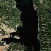
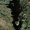
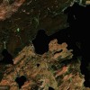
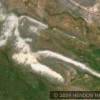
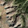
16 Spaces┬Āx 16 Spaces = 256 Total 2 Miles x 2 miles 2,560 Acres in Chess Board Wider View you can zoom in and zoom out via your cursor Light & Dark Grids are approximately 1 mile x 1 mile – 640 Acres Per GridThe Beak of the 10th Sun Raven STILL GLOWS!