Ho May Ha, Wyoming – Ancient Chinese City?
Posted on Monday, February 8th, 2010
I believe it’s no mystery why the ancient Asian settlers originally came to North America. They came for the same reason that brought people from all over the world to California in 1849. They came for the GOLD. They came for the gold and the other precious minerals and stones that were reported back to the Emperor of China by the original expedition leaders in the Shan Hai Jing. It was bound to have leaked out of the palace and when it did thousands of Asians made plans to travel to the New World (Fu Sang).
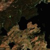
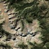
It’s important to remember that the settlers in Ho May Ha, the most northern of the original cities of the Eastern Mountains, didn’t one day discover that there was a massive gold mine in the middle of their city. They originally came because of the large gold deposits mentioned there in the SHJ and the city grew up around the mine as the mining operations and population grew. Legend has it that this city and her sister cities later to be called El Dorado by the Spanish were among the largest cities in the world in their day. Six of the twelve destination points of this expedition mentioned in the SHJ were reported to have gold deposits and the cities of El Dorado were built around these mines/gold deposits. Ho May Ha in Medicine Bow National Forest was the most northern of these mining cities. The most southern city was located at the bottom of Baldy Peak, Texas. These six mining cities are clustered in three pairs. They are all approximately 100 miles (300 li) apart from their sister city. One of them is ironically located in CIBOLA National Park.
These are the reasons for my theory:
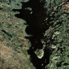
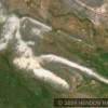
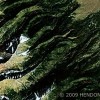
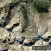
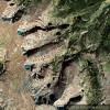
- The Shan Hai Jing journal interpreted by Edward Vining and the expedition route in Volume #4 purportedly located by Henriette Mertz (before the benefit of satellite photographs) said there were gold deposits in and around Medicine Bow Peak. In looking at Medicine Bow Peak and the immediate area north and south using satellite imaging you will notice that portion of the range is a different color from any of the other mountains in that area. It is a stark white. My first reaction was the white area were mine tailings but after closer review I could tell that was the “mined” mountain itself. The mine tailings are long gone but I believe those tailings were transported and used to color the “Harris Horse” which almost completely surrounds Ho May Ha. Is it possible that the entire eastern mountain slopes from the area close to Lake Marie to the area near Glacier Lakes was the northernmost mine in the “EL Dorado” series? For a better look as to why I believe this mountain was mined go to the “terrain map” on google maps and see the steepness of the east facing slopes. There is nothing similar in the area. However, there is another example of this type of mining at Guadalupe Peak, Texas along the southern tip of El Capitan Peak and bending around and going up the western side for miles! The Secret of the Guadalupes. What will throw you off and cause you to think that this can’t be true is the height of the cliffs. These slopes range from 800′ to 1200′ high. If these are in fact mines you are talking some serious mining here. Although I can find no evidence of mine tailings at Ho May Ha there is much evidence at Guadalupe Peak along the western side. Yes it has eroded downstream but the tailings are still visible. In addition just before you get to the bottom of Guadalupe Peak on Hwy 62/180 driving east there are several huge mounds of dirt that look to me like they could be mining sludge. The ancients didn’t hide their activities. The reason it hasn’t been discovered before now is no one has been looking to make the connection. I simply believe that Henriette Mertz located the SHJ trail and nobody until now, other than a very few of us have followed up on the evidence of this expedition.
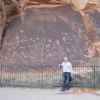
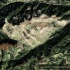
- The Lines  The Lines  The Lines—-In Ho May Ha all around the white Medine Bow Peak mine you see hundreds of parallel lines. Some of these lines are horizontal, some are vertical and others are diagonal. How is it possible for this to be a natural occurrence? I believe these lines are evidence of an ancient Asian city where the inhabitants lived.
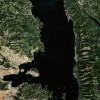
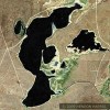
- The Lakes and Reservoirs. If you have a city with a large population you must have water for them. Rob Roy Reservoir is the largest lake in the national forest but there are many other lakes throughout the area. It’s interesting that several of these lakes have the description “reservoir” as a part of their name.
- Cinnabar Park—-Cinnabar has always had a place in Asian society. Although cinnabar is toxic because of its high mercury content it has for millennia been fascinating to Asians for numerous reasons but perhaps the most well known one being its use for the brilliant Asian red paint and lacquer. There have also been suggestions that if the ancients were in fact flying using “powered” flight that mercury was the most likely fuel source. Cinnabar is a primary source for mercury. At least one writer on ancient flight refers to “the mercury vortex engine”. Therefore, it might not come as a surprise that close to Rob Roy Reservoir is a park named “Cinnabar Park”. Is that an old cinnabar mine? If so that would be very convenient.
I believe that Ho May Ha may be an ancient Asian city for the above reasons, as well as the enormous geoglyphs all around “this city” and lastly because a major Chinese document, the Shan Hai Jing, reports this expedition here and the descriptions of each destination stop including Medicine Bow Peak match up all the way from Casper Wyoming to the Rio Grande.
The Beak of the 10th Sun Raven STILL GLOWS!