Questions
Posted on Wednesday, December 2nd, 2009
-
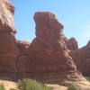
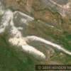
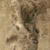
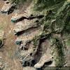
Why is there a huge white scrapped rock Rhino head image in the Lewis and Clark National Forest, Montana (It can be best seen on Google maps at 5 miles per inch and tighter.) What civilization that we know about could have done that? Do you see possible settlement marks to the south and west?
-
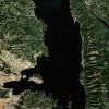
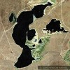
Directly south of the Rhino image why does the black water lake, Yellowstone Lake, Wyoming look like a miner holding a sledge hammer in both hands with a smaller hammer on the ground just to the west of the miner? Is it a coincidence that the island in the lake is right where the eye would be on a created miner image?
-
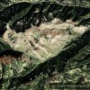
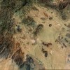
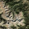
Why does there appear to be a white scrapped rock Mayan Head image in the north/east corner of the State of Washington near the Canadian border?
-
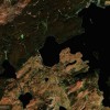
Why are there so many possible ancient settlement images on both sides of the U.S./Canadian border as you start in Vancouver B.C. and proceed east to Calgary at 2 miles per inch on the map legend?
-
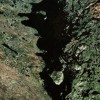
Why does the largest black water lake and the 7th largest lake in the world (Great Bear Lake, Canada) have male genetilia in the appropriate location on a headless body?What about the black water lake sea horse image just below the heel of the left foot? (Hottah Lake, Canada)? How about that island in just the right spot for the sea horse’s eye? Another coincidence?
What culture had the life experiences to know about these animals and the technology and time to craft these land images and lakes and scores of others?
The Beak of the 10th Sun Raven STILL GLOWS!
Categorized as Articles