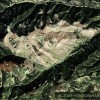
The John Fairbairn Ancient Go (Weiqi) Board in the Joseph Needham North American Chess Board Grid Collection
Posted on Tuesday, January 11th, 2011


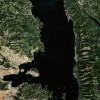
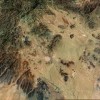
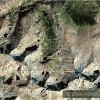
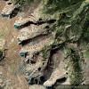
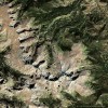
Location: South of Burnstick Lake, Alberta, Canada
Size: 2 miles x 2 miles
2560 Acres
256 Ten Acre Colored Parcels
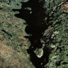
I am dedicating this Weiqi (Go)(Yi) Board geoglyph in the Joseph Needham North American Chess Board Grid Collection to John Fairbairn, author, translator and Go (Weiqi) player for over 30 years. I am making this dedication because of his article “Go in Ancient China”. The last paragraph of the article begins by commenting on an ancient poem describing the game. These closing thoughts do an excellent job of summarizing John Fairbairn’s personal feelings on the topic.
I had come across this huge geoglyph in Alberta several months ago but its importance became clear to me after I read, “Go in Ancient China”. Before his article I was focused primarily on the squares or spaces on the board. The sixteen spaces wide and sixteen spaces deep had no apparent meaning. When I realized that Go (Weiqi) is played on the lines and not in the spaces, I then understood that sixteen spaces is also seventeen lines by seventeen lines which is the exact size of an ancient Weiqi (Go) (Yi) board before its modification to the nineteen lines by nineteen lines format which remains to this day. This modification did not happen recently. Go (Weiqi) boards of 19 lines by 19 lines have been found as far back as the Sui Dynasty, 584-618 AD. Only in Tibet is Go still played on a 17 lines by 17 lines board.
I will not comment on many of the fascinating aspects of this game because of the abundance of information now available. Many books and excellent articles have been written on this subject. The internet is an excellent source for obtaining preliminary information.
Go (Weiqi) is not the only ancient Chinese board game. There were others. The two major games were/are Xiangqi and Weiqi commonly called by its Japanese name “Go” because it was introduced to the western world via Japan. I know the geoglyph I have found in Alberta, Canada is not a Xiangqi board because Xiangqi is played on board lines as well but on a completely different board. (However some ancient pictures show Go being played on a Xiangqi board. I suppose that was because no Go board was immediately available for them to use). Go and Xiangqi are very different. Xiangqi is the original game of what the world knows today as chess. Scholars debate whether the game originated in China or India. In Xiangqi as in chess there are different pieces with different names and the ability to make different moves. The object of Xiangqi is to checkmate your opponent’s dominant piece.
In Go (Weiqi) the object of the game is to control more of the board than your opponent by the end of the game. That is why the game’s name means “The Surrounding Game”. Each player has either black or white stones to place on the board and once placed the stones can not be moved except off the board. This game goes far back into Chinese prehistory and was originally known as Yi. Scholars believe in ancient times the Yi board was used for divination (fortune telling). Google: “Thoughts on Elemental Correspondences of I-Ching & Geomancy”. See how multiples of four (4) tie into the occult (divination).
Although many of you may find this interesting, you are probably wondering “why is it so large?” and “who could have done this?” The first possibility is that this work was done by surveyors. For information on that possibility I draw your attention to the Dominion Land Survey, which started in 1871, and the later Alberta Township System. For those who believe that these lines were done by surveyors I have the following questions and statements.
My understanding is that surveyors normally “shoot” visual lines and mark the corners/boundaries with markers for future reference. How often do surveyors cut timber and grade roads and when would a surveyor or anyone else ever color 256 10-acre squares contrasting alternating colors? Why are these 256 alternating colored grids only visible from the sky? Why are there so many other colored grids at several locations along the Eastern Rocky Mountains in Alberta, Canada and Montana, USA? As this “surveying” began in 1871 during the Indian Wars (before Custer lost his life at the Battle of Little Big Horn, Southern Montana 1876) who would have had the 1) money, 2) technology and 3) the incentive to color in these grids after 1871? Who could have done it previously?
A more probable possibility in my opinion is that this 2560 acre colored square with 10 acre grids was designed, completed, and colored by ancient Chinese/Native Americans for divination. An existing ancient Chinese collection of books called the Shan Hai Jing (Journal of the Mountains and the Seas) details an expedition in an unknown territory more that 4,000 years ago. The physical descriptions of the expedition encampments setup almost 100 miles apart line up perfectly with the topography, wildlife and directions the waterways flow from a starting point near Casper, Wyoming south to Chinatti Peak on the banks of the Rio Grande. The descriptions are so precise that they would fit nowhere else in the world. This route was identified by Henriette Mertz from the research of Edward Vining. What is astonishing is that although my sister and I have visited the southern three encampment areas to my knowledge no one else is researching this data. Having been to this area twice I am convinced that Mertz correctly identified the ancient expedition route.
My belief is that this journal describing specific precious metals and semi precious stones at this location precipitated a sizable migration from China to mine these resources. Alberta, Canada and Montana are north of the original expedition route but also along the eastern slope of the Rocky Mountains.
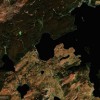
The existing geoglyphs, altered “black water” lakes, numerous settlement marks and these prominent grids seem to indicate that this area was home at one time to a large population of ancient people. These people were Shamanistic. Totems were a major part of their culture and these geoglyphs were totems.
One can look at what I’ve previously called man made geoglyphs in this same approximate area (Alberta and Montana) and claim “I just don’t see what you’re seeing”. The Badlands Guardian in Alberta, Canada for example in spite of 11 or more “markers” in the exact right location on a human body is claimed by most to be a natural land formation. There are amazingly accurate depictions on the Badlands Guardian of a human chest, shoulders and head along with many other features but they are claimed to be totally random and naturally occurring nonetheless. One can say that and possibly get away with it. However how can anyone claim that these grids all 256 (10 acres each) of them in alternating colors be a natural occurrence or formation. What about all the other grids in Alberta and in the State of Montana just below Alberta with alternating colors? Are those natural as well? That’s just not possible.
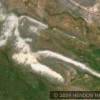
The Nazca Lines and the Marree Man are unexplained accepted facts. What will it take for these North American lines (grids) and other geoglyphs to be accepted as man made as well? I appeal to all people who care about truth in history to support the further exploration of what these unexplained geoglyphs signify. Similar geoglyphs are found in China as well. (Do you see the hummingbird in flight in the middle of the page just above the bottom line? Hummingbirds are indigenous to the Americas and not found naturally in China. How does a hummingbird image show up on an ancient geoglyph in China?) Read “Trans-Pacific Echoes and Resonances: Listening Once Again” by Joseph Needham (1985).
The Beak of the 10th Sun Raven STILL GLOWS!
The John Fairbairn Ancient Go (Weiqi) Board