Why Does Alberta Canada Use A Different Land Measuring System?
Posted on Friday, April 16th, 2010
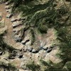
Since I made the possible connection between the Swan Hills, Alberta grids and the Zhang Heng “Bird’s Eye Map” I have been thinking about how it could be proven. I now believe it can be solved by the question ‘what measuring system was used?’
The ancient Chinese could have cared less about the mile or any other western land measurement tool that we inherited from the Romans. They had their own measurement system dating back to their earliest civilization. This system was based on the li and although the li was changed over the years the best comparison to the mile has been approximately 3 li to 1 mile.
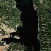
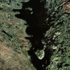
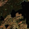
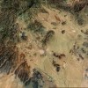
Therefore, if the Alberta grids were in fact done by the ancient Chinese then they had to be surveyed using the li. With that in mind I went to Google Maps and zoomed in on the Alberta grids to a 1 mile per 1 inch scale and downloaded several maps for my research. (Measuring the grids directly on the screen will produce different results) After I had downloaded and measured the maps I was surprised to find that there were three + grids to every inch/mile. It was not exact. It seemed to be approximately three grids to every inch and 1/8 inch. That matches the li system. To my knowledge nobody uses or refers to a 1/3 mile measurement. Now the world has largely converted over to the metric system with the United States being the lagging exception.
Within the last few days I have found out that Alberta Canada inexplicably has a separate land measuring /surveying methodology than the rest of Canada. It’s not because of present day cultural diversity as in Quebec and it’s not because the land in Alberta is that much different from the land in the other Canadian provinces. Then why?
“In 1910 The Alberta Surveyors Act prescribed the system and the methods whereby land surveys were to be carried out….”
“In principle there is a mathematical basis for the Alberta Township System (ATS) variant of the Dominion Land Survey (DLS) system as implemented in Canada.”
“This map represents the province with the Alberta Township System (ATS)….”
Is this their way of saying ….’we have inherited a massive grid system that we don’t understand but it’s so comprehensive that we intend to use it regardless of our lack of understanding on when or how it was measured or what measuring system was used to complete it.’
I could use your help. If you can join me in exploring this issue I would appreciate your time and input. If you know of a college or university that might consider researching this I would appreciate your help in gaining their assistance. I am prepared to be told of another explanation for these Alberta anomalies and that I am wrong if that is what the facts disclose. If you have the time, the contacts and the desire please join me in unraveling these mysteries.
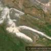
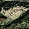
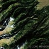
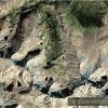
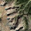
If this theory is correct and ancient Chinese lived in significant numbers in Alberta and along the eastern Rocky Mountains they would have used the li measurement  system to make their grid surveys as well as the geoglyphs, farms, settlement areas, interesting land patterns and chessboards now visible from the air.
If the use of the li in ancient Alberta can be proven it would positively place an advanced civilization in North America using the Chinese system. Who else then could it be who did it?
Click below to view maps
- New Chessboard Patterns East of Swan Hills, Alberta
- Exquisite Land Patterns in Alberta
- Settlement Marks/Land Patterns
- Land Patterns, Alberta/Who did these patterns and when?
The Beak of the 10th Sun Raven STILL GLOWS!